Vision
A globally competitive province, recognized as a prime tourist and investment destination that champions its empowered and well-rounded citizens in promoting a sustainable and disaster resilient environment with a vibrant economy, just and lasting peace, managed by an inclusive, responsive, accountable, and transparent government.
Mission
The Province shall build a safe and eco-friendly community through sustainable socio-economic development programs and projects that would improve the quality of life of the Samareños.
Goal
- Increase Investment Inflows:
-Achieve a steady rise in the number of local and foreign investments in the province within the next 3 to 5 years. - Job Creation:
Generate sustainable employment opportunities for at least 10% of the working population annually through new and expanded businesses. - Boost Local Economy:
-Contribute to a consistent increase in the province’s gross domestic product (GDP) by supporting key economic drivers. - Improve Business Satisfaction Index:
-Reach a target satisfaction rate of 85% and above from investors and entrepreneurs on government support and ease of doing business. - Develop Investment Promotion Infrastructure:
-Establish investment one-stop shops and digital platforms to assist and guide investors efficiently.
Objective
- Promote Business Investment:
-Attract local and foreign investors by creating a favorable business climate and showcasing Samar’s investment opportunities. - Enhance Local Industries and Services:
-Support the development of priority sectors such as agriculture, tourism, manufacturing, and services through capacity-building, incentives, and technical assistance. - Encourage the Use of Local Resources:
-Promote the utilization of Samar’s local materials and human resources to drive economic activities and sustainable development. - Facilitate Ease of Doing Business:
-Streamline local government procedures and regulations to ensure efficient processing of business permits and licenses. - Generate Livelihood Opportunities:
-Support micro, small, and medium enterprises (MSMEs) and cooperatives to increase employment and income-generating activities for the people of Samar. - Strengthen Public-Private Partnerships:
-Foster collaborations between government, business sector, and civil society for inclusive economic development.
A brief History of Samar
In the coming of the Spaniards in 1596, Samar Island was called in different names (Samal, Ibabao/Cibabao, Tandaya, etc.). Legend says that when the Spaniards arrived in Homonhon Island, they met a wounded man and asked the name of the place, he replied “samad”,which implies of what had happened to him for he didn’t understand Spanish. So, the word “samad” was adopted with an alteration in the last letter (from d to r). The name Samar was derivedfrom the local dialect “Samad”, meaning wound or cut, which aptly describes the rough physical features of the island that is rugged and deeply dissected by streams or a multitude of rivers dissect the island in various directions like crease-crossing wounds.
In the early days of Spanish occupation, Samar and Leyte islands were under the jurisdiction of Cebu. In 1735, Samar and Leyte were separated from Cebu and declared into one provincewith Carigara, Leyte as the capital. Consequently, during the Spanish-American colonial period, Samar was separated from Leyte and declared as a province in 1768 with Catbalogan as the provincial capital.
On June 19, 1965,RA 4221 was passed by Congress dividingSamar Island into three (3) provinces: Northern Samar with Catarman as capital, EasternSamar with Boronganas capital, and Western Samar with Catbalogan as capital. A subsequent legislation passed on June 21, 1969 (RA 5650) changed the title “Western Samar” to simply Samar.
Samar Island lies southeast of Luzon. It occupies the northernmost section of Eastern Visayas Region VIII. The province of Samar (western) occupies the southwestern part of Samar Island. It has the largest land area (559,100 has.) among the three provinces which constitute 42% of the island’s total land area and 26% of Region VIII. The San Juanico Bridge connects Samar to the province of Leyte on the southeast across the San Juanico Strait. It is bounded on the north by Northern Samar, on the east by EasternSamar, on the south by Leyte Gulf and on the west by the SamarSea. Catbalogan, the provincial capitalis 107 kilometers from TaclobanCity, the regional capital of Eastern Visayas.
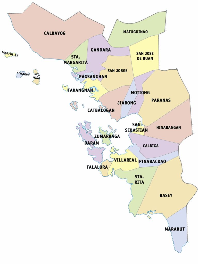
| District/City/Municipality | NO. OF BARANGAYS | LAND AREA (SQ.KM.) |
|---|---|---|
| Samar | 951 | 6,048.03 |
| A. First District | 427 | 2,269.14 |
| 1. Calbayog City | 157 | 880.74 |
| 2. Gandara | 69 | 573.49 |
| 3. Tarangnan | 41 | 132.49 |
| 4. San Jorge | 41 | 241.2 |
| 5. Sta. Margarita | 36 | 129.12 |
| 6. Almagro | 23 | 51.36 |
| 7. Matuguinao | 20 | 172.51 |
| 8. Tagapul-an | 14 | 28.7 |
| 9. Pagsanghan | 13 | 30 |
| 10. Sto. Niño | 13 | 29.53 |
| B. Second District | 524 | 3,778.89 |
| 1. Catbalogan City | 57 | 274.22 |
| 2. Daram | 58 | 140.26 |
| 3. Basey | 51 | 513.01 |
| 4. Paranas | 44 | 556.12 |
| 5. Calbiga | 41 | 283.7 |
| 6. Sta. Rita | 38 | 411.77 |
| 7. Villareal | 38 | 98.54 |
| 8. Jiabong | 34 | 67.7 |
| 9. Motiong | 30 | 174.4 |
| 10. Zumarraga | 25 | 38.55 |
| 11. Pinabacdao | 24 | 183.06 |
| 12. Marabut | 24 | 143.55 |
| 13. Hinabangan | 21 | 460.08 |
| 14. San Jose de Buan | 14 | 366.9 |
| 15. San Sebastian | 14 | 39.07 |
| 16. Talalora | 11 | 27.96 |